The Javanese Maps of 1825: A Story of Politics, Art, and Scholarship
European-style maps of Java exist in the thousands, but Javanese maps are exceedingly rare. Until recently only three specimens were known. In the National Archives of the Netherlands, a collection has recently come to light of eleven Javanese manuscript maps, dated 1825, depicting the districts of the regency of Semarang. Almost everything about these maps is a mystery. They belong together, but their visual aspects vary considerably. Some are real works of art. They turn out to be of great interest as artistic and scientific works produced at the interface of Dutch and Javanese colonial cultures, on the eve of the Java War (1825-30).
In the monumental standard work The History of Cartography (1987–2015), Joseph Schwartzberg writes: “The few known surviving regional maps from the Malay world form a remarkably disparate group. In all, there are one map of western Javanese provenance, presumably of the late sixteenth century; another enigmatic and undatable batik map from either eastern Java or Bali; a third map from east-central Java, probably drawn in the mid-nineteenth century; and finally, a map from western Borneo tentatively dated 1826. There is no indication that any two of these were informed by a common cartographic tradition.” 1
The author was unaware that the National Archives of the Netherlands house a collection of eleven Javanese maps. Made in 1825, these depict the districts of what then was the regency (kabupaten) of Semarang, part of the residency of the same name. One of them is closely related to the third on Schwartzberg’s list, which is kept in the Bibliothèque nationale de France, but the other ten are, as far as is known, unique. They are not mentioned in later studies about cartography in Southeast Asia, nor is the Paris map.
In 1876, the year the collection was acquired, the State Archivist described it as “eleven [maps] of Samarang Residency, produced by natives in their peculiar style, of which one is unlikely to find many examples in European collections.” 2 van de residentie Samarang, door inlanders in hunnen eigenaardigen stijl vervaardigd, waarvan men waarschijnlijk in Europesche verzamelingen niet vele voorbeelden zal aantreffen” (L. Ph. C. van den Bergh, “Verslag van den Rijksarchivaris aangaande het Rijksarchief gedurende 1876,” Nederlandsche Staats-Courant 91 (19 April 1877): 6).] Not only are they works of art and cartographic science of a variety largely unknown. They are also sources of new scholarly insights into Javanese culture and history, as well as significant heritage produced at the interface of Javanese and European cultures.
Maps, makers, users
The eleven Javanese topographical maps in the National Archives are manuscripts of varying dimensions on conglutinated sheets of European rag paper. Most have colour codings in pastel colours, and their labels and legends are in Javanese characters. Their styles vary considerably [Figs. 1-2]. No contextual information survives about their provenance, but several have colophons that reveal that they were made by or for the demang (district head) of the district central to a given map. Inasmuch as the maps are dated, most purport to be from April 1825. Although they follow different cartographic standards, their dating, their being signed by a district head or his representative, and the fact that together they cover the area of Semarang regency, indicate that they were produced in the same historical context. Presumably, this was for the same purposes. These purposes, however, are unknown.
Who ordered the maps to be made is not mentioned. That this was an authoritative person or body is apparent from one of the colophons: the map in question is “respectfully presented” (katur) by the “Commissioned Assistant District Head” (Asisten Pulmak Demang Dhistrik) on such and such a date. It may have been the office of the (Javanese) Regent or the (Dutch) Resident of Semarang.
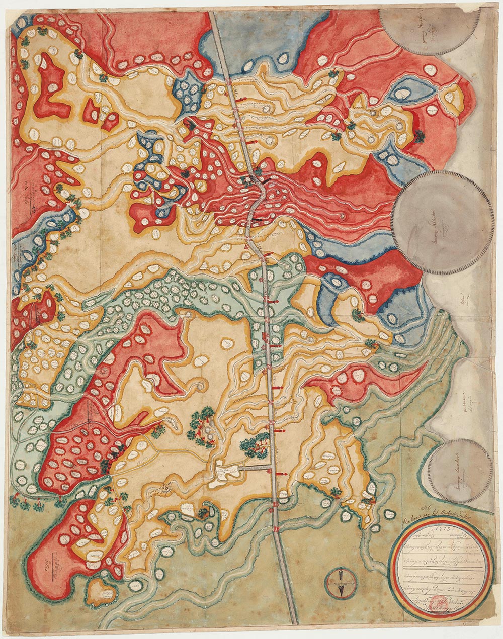
Fig. 1: Map of the district of Tingkir. (Source: Nationaal Archief)
The maps show, among other information, where the district in question bordered on other districts. They also depict major roads and rivers as well as the locations of towns, villages, and hamlets. Sometimes, other information is included as well – e.g., “parcels” (private estates, which were mostly owned by Europeans), a few specific buildings, natural features like volcanoes and even some trees, and the like. Some indicate distances along the main roads. All of this suggests that the maps served a variety of purposes relevant to the authorities: travel and transport, water infrastructure, administrative division, knowledge of habitation and the natural environment.
These were tense times. A few months later, the Java War would erupt (July 1825-1830), an uprising against colonial domination animated by the famous Prince Diponegoro. 3 The war would rage in some of the districts depicted on these maps. Less than five months after he signed and stamped his map, one district head, under the supreme command of a renowned Java-born Dutch planter, led 300 men to battle against an insurgent Javanese lord and his followers. 4 To be sure, there is no hint that these particular maps played a role in the war. But undoubtedly some of the area-specific technical knowledge recorded in them did. The maps and the uprisings sprang from the same cultural and political ambience. Area, territory, roads and waterways, power, the European presence, colonial economics, population: these issues were on the agenda of both Dutch and Javanese rulers and lived among the inhabitants.
Have these maps ever been used? Their labels and legends are almost all in Javanese language and script, but some are provided with a Dutch clarification that reveals local knowledge. This suggests that the maps came into the hands of local Dutch authorities relatively soon. As noted, they may in fact have been made for the Semarang residency office. Although parts of the maps were thus perused by Dutch-reading and -writing people, whether Javanese-reading people ever used them is an open question. At any rate, over 50 years later, the maps were acquired by the National Archives from a book trader in Arnhem as part of the map collection of retired colonial official G. J. C. Schneither (1795–1877). Schneither had been private secretary to Governor-General G. A. G. P. van der Capellen (in office 1816-26) and owned many of the latter’s archival records. 5 The maps may once have belonged together with these records. This would mean that they ended up in Batavia and were brought to the Netherlands by Schneither.
Certain features of the maps demonstrate that their makers were acquainted with European maps or cartography. An evident case is the compass rose, which appears, in various shapes, on most of the maps. The maps’ scales are never indicated and vary widely. Across different maps the same area tends to be represented with rather different contours. Usually the south is at the top, but not always. The colour codes vary as well, as do the other symbols, and not all maps provide the same types of topographic information. The rounded shapes and bright colours on the maps call to mind Javanese batik in the north-coast style. Some maps contain iconic symbols, such as the trees in Figure 1, that resemble manuscript illustrations from the scriptorium of the Regent of Semarang in 1812, whose style has been described by one of us as “unusual in comparison with other examples of Javanese pictorial art. While it cannot be called European, it is certainly more naturalistic than Javanese drawing generally.” 6 It is clear, then, that Javanese cartography as represented in this collection was not strongly standardized (in line with Schwartzberg’s impression quoted above), that the person or institution commissioning the maps did not stipulate strict and uniform rules for their making, and that (with exceptions) no measurements were taken as part of the surveying. At the same time, however, the maps were definitely not created in a pictorial and cartographic void.
The map of Srondhol District
As an example, let us briefly consider the map of the district of Srondhol [Fig. 2]. Cartographically and artistically this may be the most minimalist map in the collection. It is undated and unsigned. The different background colours denoting districts are listed in a key top-left. In the middle, top to bottom, runs a road. Another road runs to the left along the bottom. The former is the road connecting Semarang to the court cities in the interior, the latter is part of the infamous Great Post Road. Curly rivers criss-cross the map. In the top-right, three mountains loom. The map is dotted with more than 150 white blobs, each enclosing a toponym in Javanese script, symbolizing settlements.
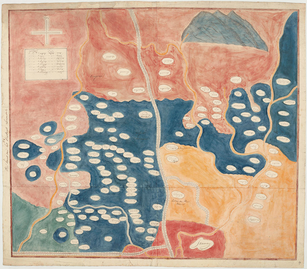
Fig. 2: Map of the district of Srondhol. (Source: Nationaal Archief)
In addition to these elements, the other maps depict more: bridges, milestones, stopping places, and numerous other features, varying from map to map. Thus there is no sign on the map of Srondhol of an interest in places of special cultural significance, like the location of the Battle of Srondhol or Jatingaleh 14 years earlier, where Dutch troops and Javanese from the inland royal courts failed miserably to prevent the British from establishing themselves in Java. 7 Even the military barracks that were in operation at Srondhol when the map was made are not marked. In similar vein, Gedhong Batu (‘Stone Edifice’), the Sino-Islamic cave sanctuary and pilgrimage site that is famous to this day, is just another blob and name. There may be several reasons why such places or their unique features are lacking. Perhaps they were not essential to the map’s function, or perhaps the requisite time, expertise, or local knowledge was unavailable. On the other hand, this map is one of only four or five featuring a separate background colour (here: yellow, or rather orange, in the bottom-right corner) to identify an area consisting of private estates, some of which (like on other maps) are identified by the names of their European lessees. Comparison with the other maps is likely to yield further meaningful patterns.
The map’s iconicity is noteworthy, especially when contrasted with European cartography. The roads are grey and white, probably like the stone with which they were paved. Most of the rivers are painted light brown, their actual colour. Even the blobs with settlement names can be seen as iconic: Javanese hamlets and villages were enclaves in rice fields, dry fields, or wilderness. Some of the toponyms are descriptive, including Pasayangan (place of coppersmiths), Pandheyan (of blacksmiths), Pedhalangan (of puppeteers), Mranggen (of sheathers), and Pasapen (of pack-cows and their herders). No doubt in the bustling city of Semarang, such specialists and their work were much in demand. Unlike the rest of the map, the mountains – Mt. Ungaran and other volcanoes – are painted in perspective. Together with the placement of the labels, this positions the reader at the bottom, in the north, in Semarang, looking southwards towards the highlands in the interior of Java, beyond which the courts are located. Like in the other maps in the collection, Dutch translations were later scribbled near some of the Javanese labels, by people with local knowledge who did not read Javanese. 8 But one label on this map was written in Roman letters from the outset: Samarang [Fig. 3]. This, the colonial metropole, was the mapmakers’ vantage point.
Retelling the story behind the maps
These maps are of scholarly interest on several interconnected planes. Firstly, in their capacity as manuscripts, they are promising objects of art-historical, textual, codicological, and philological analysis, eminently suitable to serve as focal artefacts in a study of worldmaking. 9 Secondly, they provide insights into Javanese cartography, a field of study still in its infancy. The artistry of some of the maps is remarkable, but they are also significant as products of Javanese scientific practice. Thirdly, different as they are from the usual sources, these maps cast a new light on Javanese-colonial culture and its history. Their analysis and contextualization is yielding insights into Javanese spatial orientation and changing conceptions of area and place, as well as their visual representation. They reveal a variable interplay between Western and Native traditions regarding these matters. However Javanese they were, in key regards the maps were colonial by design. Their makers dated them in the Gregorian rather than the Muslim-Javanese calendar used at the courts. Not only did European elements feature among their cartographic methods and conventions, the areas that formed the maps’ basic organizational and representational principle were districts (dhistrik, dhestrik). These belonged to a European administrative division of Java that had been imposed quite recently. And indeed, European governors in the preceding three decades – Nicolaus Engelhard, Herman Willem Daendels, Raffles, Van der Capellen – had entertained a pronounced interest in mapping.
Fourthly, in conjunction with contextual study, the maps afford new insights into the history of Semarang and the areas to its south and east. This region was important for all of Java. By 1825, Semarang was one residency among many, but during the 18th century, under the VOC (Verenigde Oostindische Compagnie, United East India Company), the city had been the capital of the government of Java’s North-Eastern Coast. The regents of Semarang 10 were patrons of arts and culture in the early 19th century. 11 The Dutch resident at the time the maps were made, H. J. Domis (1782–1842), had scholarly interests. 12 Towards the south, Semarang regency (and residency) bordered on the sultanate of Yogyakarta and the sunanate of Surakarta. The districts on the eleven maps are clustered around the northern two-thirds of the main thoroughfare connecting the Dutch administrative centre of Semarang and the former royal capital of Kartasura, where it forked to Yogyakarta and Surakarta. This major channel for travel, transport, communication, and interaction was of key political and economic importance. Just to the east of Semarang lay Demak, the location of the oldest and most venerable mosque of Java. The entire region was the theatre of serious socio-political tensions, which would soon erupt into violence.
Finally, as mentioned, these maps are Dutch–Indonesian cultural heritage. Apart from their general interest, 13 this gives them theoretical significance. In these maps, Javanese and Dutch components are fused into a rounded whole. This in itself is nothing special, but ostensibly these maps were produced in a period when the manner and degree to which Javanese and Dutch elements could be adapted to each other were still negotiable. This happened in different ways on these maps, allowing us to observe the give and take of intercultural (inter-scholarly, inter-artistic, inter-political) encounter comparatively within a single set of artefacts.
It is for these reasons that in 2022, a team of researchers based at Leiden University in the Netherlands and Universitas Sebelas Maret in Indonesia – the authors of this article – joined hands to describe and interpret the collection and bring it to life. 14 The aim is to uncover the story behind these eleven maps, and to retell it in a jointly authored book.
Bernard Arps is Professor of Indonesian and Javanese Language and Culture at Leiden University, where he teaches area studies theory, cultural politics in Southeast Asia, and Javanese. He has published, among others, Tall Tree, Nest of the Wind: A Study in Performance Philology (NUS Press, 2016). Email: b.arps@hum.leidenuniv.nl.
Siti Muslifah is a Lecturer in the Javanese Literature Programme, Universitas Sebelas Maret, Surakarta, and a doctoral student at the Indonesian Art Institute (ISI) of Surakarta. She researchers, among other things, classical Javanese literature and potehi puppetry. Email: sitimuslifah_avantgarde@staff.uns.ac.id.
Asti Kurniawati is a Lecturer in History at Sebelas Maret University in Surakarta. She has interests in educational, urban, cultural, and social history. Her publications include Membangun (?) Narasi, Menghadirkan Pesona: Akar dan Perjalanan Citra Yogyakarta ‘Kota Pendidikan’ (Ombak, 2012). Email: astikurniawati.fib@gmail.com.