Anchoring maritime crossings. Coastal heritage of the Bay of Bengal
The objective of this essay is to highlight the important role of coastal architecture in fostering maritime connectivity and to bring coastal monuments on the east coast of India into dialogue with those located across the Bay of Bengal for a holistic understanding of maritime cultural heritage both in the past, as well as its continued significance in the present. The demarcation of sea spaces may be understood through intellectual traditions of writing, but more importantly through an active engagement with the nature of coastal installations that physically circumscribed the seafaring world and framed interactions of several travelling groups. The presence of coastal shrines affiliated to Christianity, Islam, Hinduism and Buddhism are indicative of the shared cultural traditions that spread across the Bay of Bengal.
I start with briefly highlighting the contribution of James Rennell (1742-1830) as he surveyed and mapped the river Ganga in Bengal under the aegis of the East India Company, which had established control over eastern India in the 18th century and had occupied Penang in the Straits of Malacca in 1786. In the 19th century, a hydrographic survey of the Indian coastal areas was undertaken and in 1878 Clements R. Markham, Secretary of the Royal Geographic Society published in one volume the history of British Indian marine surveys. What was the nature of sailing networks prior to the establishment of colonies in eastern India and the Malay peninsula by the East India Company? The methodology adopted here is to focus on the deep history of coastal shrines and to trace transformations and continuities along the east coast of India and other sites across the Bay of Bengal dating from the beginning of the Common Era, to highlight the multiple ways in which shrines provided anchorage to sailing groups prior to the development of oceanography and the nautical charts of the 19th century. Also of interest is the changing nature of sailing networks as a result of the introduction of new technologies and the increasing mechanisation of ships.
James Rennell, considered the father of oceanography, was the first to take advantage of the development of the chronometer towards the end of the 18th century, which made it possible to collect information on ocean currents on a wide scale. In 1760 he secured a place as a midshipman on the frigate America and sailed for Madras on the southeast coast of India. After six years of meritorious service and having made charts not only of the Tamil coast, but also of the Nicobar Islands, Malacca and northwest Borneo, Rennell left the British navy in 1763. The following year he had procured a commission as Surveyor-General of the East India Company's dominions in Bengal and in the autumn of 1764, he commenced work on surveying the river Ganga. The innumerable streams of the Ganga delta intersected each other in a maze, and only one of the streams, namely the Candana, which flowed from the Padma to the Bay of Bengal through the Harinaghata estuary, was navigable throughout the year. Between 1764 and 1772, Rennell explored for the East India Company the lower reaches of the Ganga, in what is at present known as the Sunderbans, in search of the shortest route from Baratala or Channel Creek to the river Padma.
After his return to England, in 1778, Rennell spent his time on study and research. In 1779, he published the Bengal Atlas comprising several large-scale maps of Bengal based on his fieldwork. He then started work on the Memoir of a Map of Hindoostan, a purely geographical work. Without a doubt, hydrographic surveys and scientific mapping initiated attempts to tame rivers and control the coastal areas of Bengal by the East India Company. This was different from strategies adopted by other European Companies who had established enclaves in India in the 16th and 17th centuries, as examined in the next section.
European architecture along the east coast of India
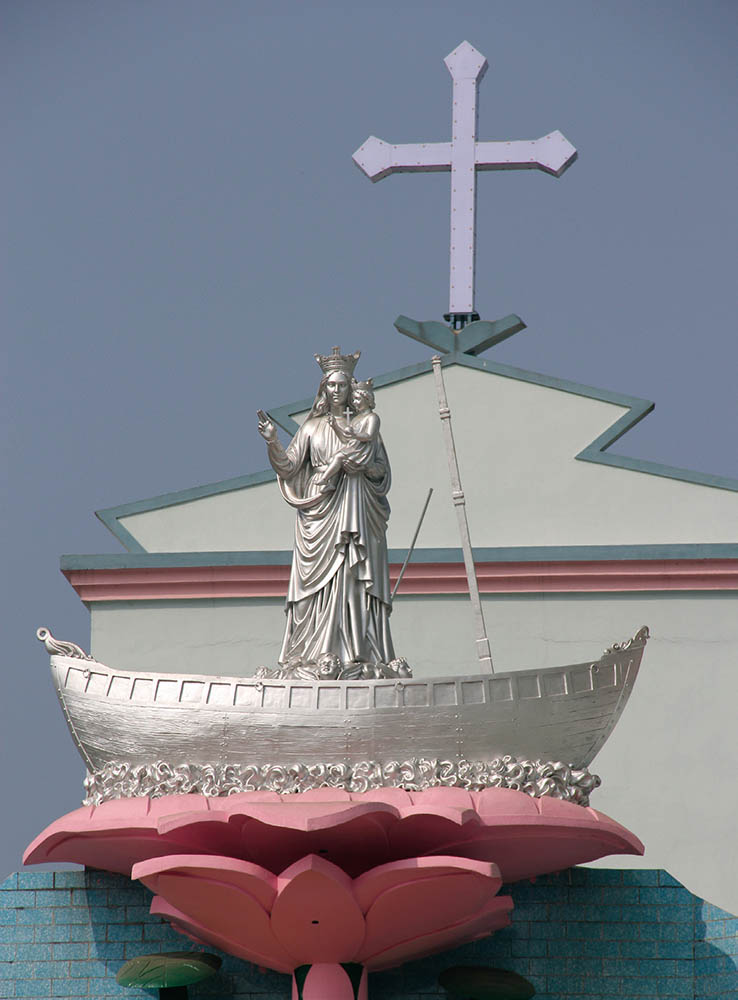
With the entry of the European trading companies in the Bay of Bengal, new forms of architecture developed along the east coast of the subcontinent comprising not only port cities, such as Calcutta and Madras, but also churches, forts and cemeteries. For example, the Portuguese had established their settlement at Bandel in the 1530s in the vicinity of Satgaon on the river Hooghly, the principal distributary of the Ganga. A monastery and church were built at Bandel in 1599 dedicated to Our Lady of the Happy Voyage who saved her worshippers from shipwreck. The church was burnt down during the Mughal siege of 1632, but the image was saved and still adorns the renovated church (fig. 1). The mast of a ship was dedicated to the church in 1655 by the captain of a Portuguese ship who survived a storm due to the grace of the Virgin Mary. Another 16th century church was built by the Portuguese further south along the Tamil coast at Velankanni, about 300 km south of Madras (present Chennai). It is dedicated to Our Blessed Mother Mary, the ‘Star of the Sea’ who is said to have saved a Portuguese merchant vessel sailing to Colombo in Sri Lanka from shipwreck. The grateful sailors built the church as a mark of their reverence.

Fig. 1: Replica of Our Lady of the Happy Voyage at Bandel church built by the Portuguese.
The notion of a deity saving her devotees from shipwreck goes back to an even earlier period along the east coast. The goddess Tara is featured prominently in the monastic establishment at Ratnagiri in present day Odisha. It was in Odisha that the major expansion of Buddhism took place from the 5th to 13th centuries and the stupendous monastic complexes of Ratnagiri, Udayagiri and Lalitagiri were constructed in the hill ranges of Jajpur district. Two standing images of aṣṭamahābhaya (the goddess as saviour) Tara saving her devotees from the eight perils, including shipwreck, were found at Ratnagiri. One of these is in Patna Museum, while the other is preserved at Ratnagiri itself.
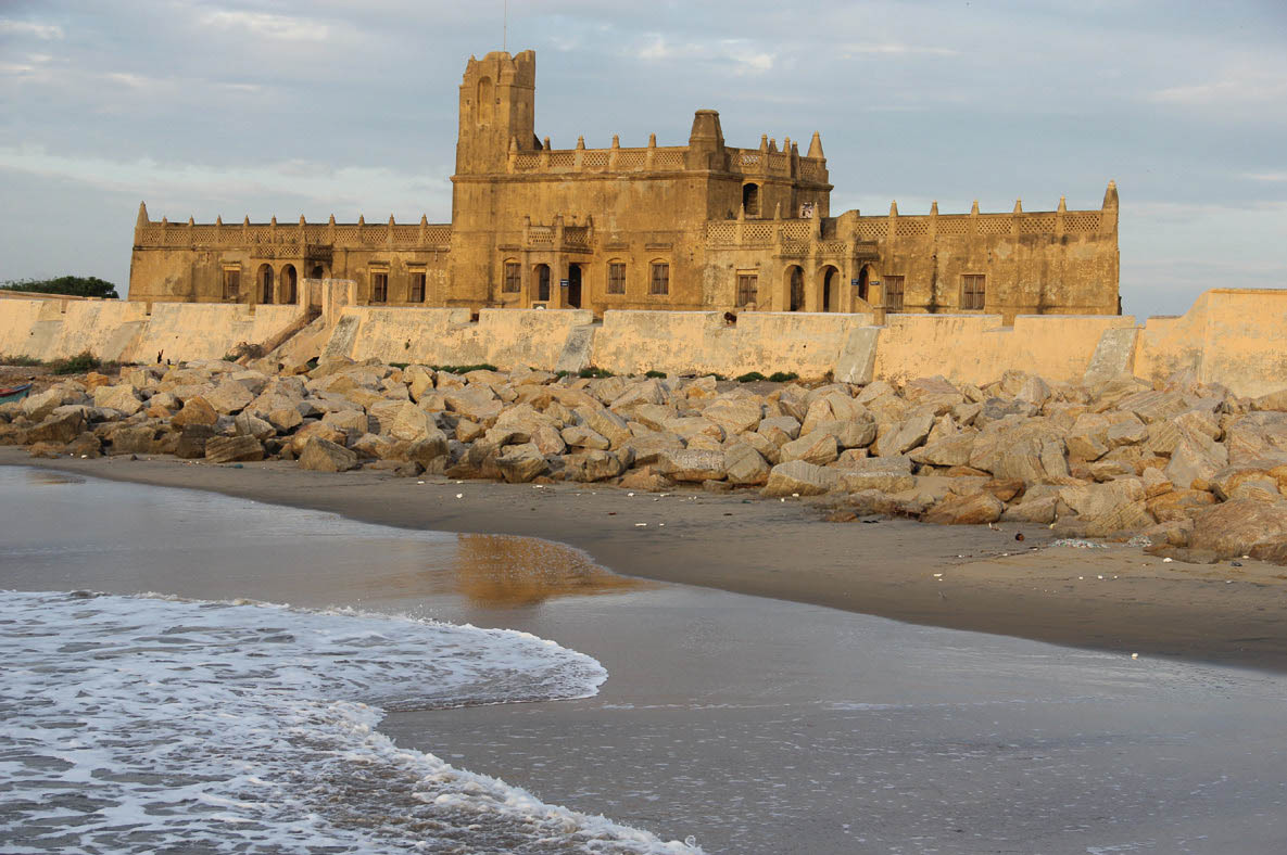
In addition to the setting up of churches, the entry of Europeans in the Bay of Bengal led to the demarcation of space for graves and tombs and many cemeteries still survive along the east coast. One of these is the Cemetery of Dinamardinga at the town of Balasore in Odisha. Another cemetery is inside the fort at Sadras, 15 km south of Mahabalipuram, which was built by the Dutch in 1648. The Dutch lost Sadras to the British after the siege of 1780, though they regained control for a short time from 1818 to 1854. The nineteen graves at Sadras date from 1620 to 1769.Another example of European heritage is evident in the case of Tranquebar (Tharangambadi), a small fishing town on the coast of Tamil Nadu, which was a Danish trading colony from 1620 to 1845, when it was sold to the British. The first Protestant church was founded in Tranquebar in 1707, and the core of the settlement was fort Dansborg, locally known as the Danish fort (fig.2).

Fig. 2: Danish fort at Tarangambadi constructed in 1620 by Naval Col. Ove Geddy with the permission of King Raghunath Nayakkar of Thanjavur. The fort consists of two levels. The lower level was used as godown, prison and resting area for soldiers while the upper floor was the residence of the governor and priests.
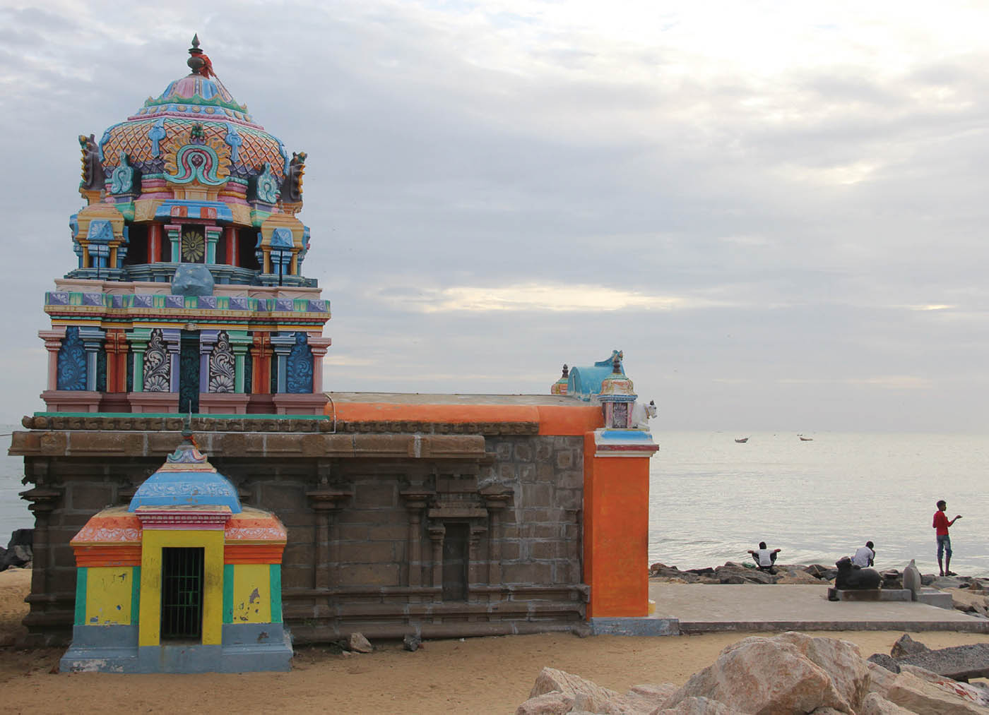
The Danish East India Company was established in Copenhagen in 1616 and a mission was sent to India with Admiral Ove Gjedde (1594-1660). He signed a treaty with the king of Tanjore (Thanjavur), after which the fort was established. However, what is overlooked in the process is the pre-European settlement at the same location, and the complex relationship between the trading post and the kings of Tanjore to whom the Danes paid tribute. For example, a Masilamani Nathar temple to Shiva, dating from the early 14th century, still stands in Tranquebar and continues to be in worship by the local communities (fig.3).

Fig. 3: 14th century Siva temple on the sea coast at Tharangambadi, which continues to be worshipped by local communities.
The temple would have been a major centre coterminous with the presence of the Danes in the 17th century since the Tanjore court patronised the devadasis [female dancers] serving at temples not only in Tanjore and Tranquebar, but also in larger towns such as Tiruvarur, forty kilometres southwest of Tranquebar. Thus, Tranquebar was a part of the cultural network of Tanjore and its ruling elite. The example of the Tanjore court sponsoring ritual performances at temples is indicative of the social role of the Hindu temples and the participation of the political elite in sponsoring a range of activities, as discussed in a longer study that examines the importance of the coastal shrine in sailing networks in the ancient period.1
Pre-European maritime networks across the Bay of Bengal
It is apparent that the maritime landscape was by no means the result of only European initiative, and this is further corroborated by the history of the town of Nagapattinam, 35 km south of Tranquebar. Tamil tradition refers to the semi-legendary saint Shahul Hamid of Nagore, whose 16th century shrine is situated a few kilometres to the north of Nagapattinam. The site had several benefactors all of whom contributed to structural additions to the shrine, including Maraikayar ship-owners, Nayak rulers, as also the Dutch East India Company. In the 11th and 12th centuries, the King of Srivijaya (Sumatra) and Chinese patrons made donations to the Buddhist temple at Nagapattinam. This trans-oceanic mobility should not be seen as an isolated event, but as a continuation of a long cultural process across maritime routes connecting the southeast coast of India to Sumatra, Vietnam and China, that had roots in the 1st millennium BCE. These Iron Age networks underwent changes around the 2nd /1st century BCE as Buddhist monastic centres came to be established. Temples affiliated to Buddhism continued along the Tamil coast well into the 16th century. It would be useful at this stage to shift focus and to trace the beginnings of Buddhist monastic centres on the east coast and indicate their linkages with those across the sea.
In the coastal region of Andhra the presence of Buddhist structures clearly coincides with the 3rd century BCE Mauryan period; indicators of contact include Asokan inscriptions in the Kurnool district, and a fragmentary pillar inscription at Amaravati. Current evidence shows that the extant architectural components of the early Amaravati stupa in the Krishna valley mostly date from the post-Maurya period (ca. 200-100 BCE). The stupa was enlarged around 50 BCE and the railing was gradually constructed between 50 BCE and 250 CE. The bulk of the sculptural pieces also date from this period. Contemporaries of the Amaravati stupa are other Buddhist sites such as Jaggayyapeta, Vaddamanu and Garikapadu, which were also established or enlarged about the same time. Along the Krishna river, the Kesanapalli stupa was built in the plateau area and the Bhattiprolu stupa near the mouth of the river Krishna and also perhaps the Ghantasala stupa in the deltaic region. 140 early (300 BCE-300 CE) historic sites in Andhra are known, concentrated along river valleys and the coast.
Further south, a major Buddhist site on the Tamil coast was that of Pallavaniswaram at Kaveripumpattinam, which was excavated by the Archaeological Survey of India over several seasons in the 1960s and 1970s. It yielded remains from the 2nd century BCE to 6th century CE. A Buddhist vihara, Buddhapada and temples from the 4th and 5th centuries CE, as well as a small bronze image of the Buddha, were unearthed during excavations. This brief overview shows the presence of Buddhist monastic sites all along the east coast from the 3rd century BCE onward. It may be mentioned that Amaravati was the largest and longest lasting Buddhist site on the Andhra coast, which continued to be revered by pilgrims from across the seas from 300 BCE well into the 13th century CE. These Buddhist sites not only received donations from the local elite such as the raja or king, but also from a wider community of lay devotees across the seas.
The lower Irrawaddy valley
The oldest surviving examples of Pali in the world were inscribed on gold and silver and placed in the Khin Ba relic chamber at Sri Ksetra located along the Irrawaddy river that flows north to south in present Myanmar. The site is described as an important Pyu settlement; the term Pyu being used to define a population group with shared characteristics including funerary customs. Inscriptions from the valley in Prakrit, Pali and Pyu originate from the 3rd to 13th centuries CE. It is suggested that the sizes of bricks used at Sri Ksetra match those known from early sites in Andhra and date from the 1st century BCE to 1st century CE. 4th and 5th century Buddhist and Hindu artefacts have been found in the burial terraces around Sri Ksetra, including Buddhist clay sealings and Visnu images. Around the middle of the 1st millennium CE, pottery urns gave way to large stone urns, cylindrical in shape with a flat base. Five such stone burial urns with one-line inscriptions in Pyu were excavated 70m south of the Payagyi Stupa, outside the northwest walls of the city at Sri Ksetra, indicating names of Sanskritic origin of elite groups using the urns for royal burials.
The Khin Ba mound is a part of the cluster of three stupas, many stepped burial terraces, city walls and moats. These stupas are considered some of the earliest Buddhist monuments in the country and date from the middle of the first millennium CE. An outstanding find inside the brick-lined relic chamber was a manuscript of twenty gold leaves in the form of a palm-leaf manuscript inscribed with excerpts from eight Canonical texts. The sandstone slabs covering the relic chamber were carved in low relief and showed an ‘Andhra style’ stupa with five tiers of chhatras or umbrella-like structures. Clearly the enshrinement of relics shared several features in the two regions of coastal Andhra and the Irrawaddy valley, though practices varied in other parts of the subcontinent, such as coastal Odisha. Subsequent research has focussed on identification of Pyu inscription (inventory number PYU040) held at the Hanthawaddy Archaeological Museum in Bago, Burma, and its possible links to the Andhra region. Another region of interest is the west coast of the Malay peninsula dotted with caves and shrines affiliated with both Hinduism and Buddhism. Did these ancient coastal temples have relevance in the 17th and 18th centuries, after the entry of the Europeans in the Bay of Bengal?
The coastal temples
The temples on the east coast of India were often referred to as pagodas by European sailors and provided an easy means of identification of regional centres. Mahabalipuram, 55 km south of Madras, was known by seamen as the Seven Pagodas; the Sun temple at Konarak on the Orissa coast was called the Black Pagoda. Interestingly another temple site referred to in sailors’ accounts is the White Pagoda, or the temple of Jagannatha in Puri, Odisha and the Chinese pagoda at Nagapattinam on the Tamil coast. All these temples were monumental structures dating from the 9th to 14th centuries CE. Their construction at strategically chosen locations made them easily visible to sailors, merchants and travellers, when approaching the coast.
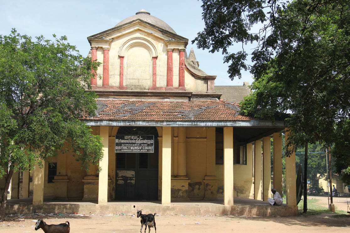
The 13th century sun temple at Konarak, on the shores of the Bay of Bengal, faces the rising sun. This temple is a monumental representation of the sun god Surya’s chariot; its 24 wheels are decorated with symbolic designs, and it is led by a team of six horses. While secondary writings refer to Tamil merchant guilds and Arab and Persian merchants in the 13th century, much less is known about the participation of the Odisha coast in Bay of Bengal’s maritime networks.Mahabalipuram is located on the River Palar, which joins the sea at Sadras, about 50 km to the north. The site comprises rock-cut cave temples, nine monolithic shrines known locally as rathas, three structural temples referred to as Shore temples, and several rock-cut images that dot the area along the coast. Human activity in the area started in the Iron Age and continued well into the present. Several European travellers, such as William Chambers who visited Mahabalipuram in 1772 and 1776, refer to local memory that mentions several temples on the coast, some of which are described as having been swallowed by the sea. Another traveller, J.W. Coombes, stated that the pagodas once stood on the edge of the shore, and their copper domes reflected sunlight and served as nautical landmarks. There is also evidence of a lighthouse on the rocks behind the temples and caves. The so-called Chinese Pagoda at Nagapattinam no longer survives as it was demolished by French Jesuits in the 19th century to make way for a college building (fig.4). How do these coastal structures inform us about the nature of sailing across the Bay of Bengal?

Fig. 4: The Jesuit college built at Nagapattinam after demolition of the Buddhist temple in the 19th century. The building is at present used as District Court.
Trans-oceanic maritime connectivity: transformations
Maritime connectivity is traditionally discussed as a network of shipping routes, each linking two or more coastal landing places. Scholars have argued that before the invention of the steamship, maritime navigation was practiced as a circuit rather than as a simple return journey between two coastal centres. This was due to winds and currents, but also had to do with the sale of commodities on board: triangular trade typically exported cargoes to places where they were needed without necessarily importing goods from the same place; rather, chains of circulation were established in order to rectify trade imbalances and draw profit from regional demand.
Two island groups that are important for this discussion are the Andaman and Nicobar Islands located between India, Myanmar and Sumatra. The Andaman Islands show less compelling evidence of linguistic contact with Malay or other Southeast Asian speech communities, though morphological similarities between Nicobarese and Malayo-Polynesian languages have been pointed out by scholars. Archaeological research conducted on the Andamans has investigated the nature and extent of contact between the Andaman archipelago and the neighbouring regions, even though the islanders have been represented as hostile to outsiders in historical accounts. Rigorous archaeological research has shown that the Andaman Islanders were hunter-gatherers who nonetheless made ceramics and kept domestic pigs. They appear in textual sources from around the 2nd century CE and radiocarbon dating conducted at the large limestone cave known as the Hava Beel Cave on Baratang Island would seem to confirm that the islands may have been occupied from the early centuries of the Common Era onward.
These links were altered around the 16th and 17th centuries as maritime networks shifted with the entry of Europeans in the Indian Ocean, and with developments of ship-building technology. It was in the 1860s that regular cargo services entered the ocean with the establishment of the liner companies. The all-weather steam vessel was larger, faster, safer and more reliable than indigenous craft on long-haul coastal and trans-oceanic voyages. This resulted in the indigenous sailing craft being driven to short-haul marginal and feeder routes. Reduced demand for cargo carrying meant reduction in the number of vessels being constructed and the closure of traditional boat-building yards. The skilled manpower required for manning these mechanised vessels could no longer be provided by the littoral sailing communities, and this led to the marginalisation of coastal groups to traditional fishing activities. These operations are now in turn being threatened by mechanisation, the introduction of commercial fishing and coastal degradation.
The engagement of the British East India Company with the countries of the Indian Ocean was of a different order from that of its predecessors. The establishment of colonies in South and Southeast Asia resulted in the introduction of new disciplines, which had far-reaching implications for the cultural identity of the sea and the communities who navigated across it. The 19th century thus raised a different set of issues with the colonisation of large parts of South and Southeast Asia. Micro-studies across disciplines are critical to an understanding of the dynamic nature of trans-oceanic exchanges as well as the diverse communities involved in these networks. It is nevertheless judicious to include large swathes of time to appreciate the transformations and continuities that characterised trans-oceanic cultural interactions. Coastal architecture and heritage is admired for its aesthetics, but more importantly there is a need to research the monuments within their larger cultural networks and links across the seas. This deeper history is essential not only for the protection and preservation of maritime heritage, but more so for a holistic understanding of sea spaces.
Himanshu Prabha Ray, Research Fellow, Oxford Centre for Hindu Studies, Oxford