Ruins of living and dead in the Himalayan borderlands
While ruins might appear to be mere physical sights of decay and disintegration, they are much more than that. Every ruin is a witness to its own cycle of life and death and the entire gamut of processes which encompass socio-political and economic events in an area. Ruins can be unique yet interconnected and share commonalities; tangible as well as intangible through the passage of time. As humans are in a continuous state of movement, societies have been in a contiguous pursuit of constructing and deserting the signs of their cultural traits. Thus, the formation of ruins is unceasing and revealing of the past. This essay looks at the tangible and intangible ruins of the Western and Eastern Himalayas.
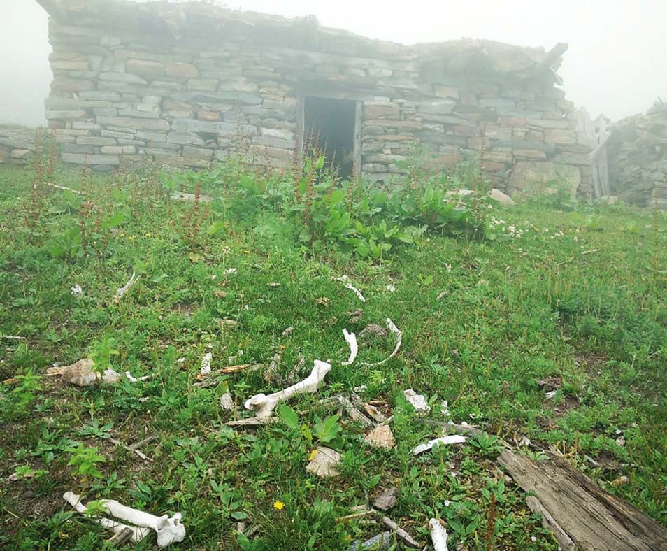
As one moves along Runang-Kanda, a high-altitude pasture above the tree-line in Kinnaur district of Indian Western Himalaya, one is almost certain to be startled by the sheer scale of the remains of cattle carcasses strewn amid abandoned and dilapidated stone houses in this area. What is even more astonishing is the addition of newer skeletal remains of domestic animals every year. A closer look suggests that the carcasses are mostly of younger animals. Naturally one would wonder why there are so many deaths at one place and what happened to the stone houses and agricultural terraces present there? Is it some kind of peculiar site or is it just what ruins look like?
The harsh environmental conditions of the Himalayas have resulted in a fragile ecology in which seasonal upkeep of man-made structures, such as houses, animal sheds, temples, monasteries, agricultural fields, and so forth, is required on a regular basis. As people move away from the area, due to either social, political or environmental factors, or even a combination of all of these, such physical structures are destroyed by environmental events like avalanches, flash-floods, landslides, and incrementally by seasonal and diurnal freeze and thaw, which acts upon these structures with variable degrees depending upon the location.
Temperature and precipitation patterns have undergone considerable changes in the last few hundred years, and have directly influenced the growing season, thereby limiting the carrying capacity of the area. The impact of climate change is magnified manifold in the fragile Himalayan highlands. Throughout history, since its creation 50 million years ago, this mountain system has undergone periods of cooling and warming. Warming led to the retreat of Himalayan glaciers, which exposed newer and higher areas suitable for human activities, while cooling led to glaciers advancing down to lower levels impacting the growing seasons and rendering higher human settlements largely untenable. Thus, the climatic fluctuations in the area’s geological history shepherded human migration across different passes and valleys, from higher to relatively lower altitudes. As people responded to the rhythms of the climatic events, newer villages were created, and older ones were abandoned.
Mental maps as intangible ruins
When people moved they transmitted ideas, imaginations, technologies, rituals and habits from one place to another. Across this journey of time and space, people preserved and remembered these changes through rituals and legends associated with certain areas and places; while at many other such sites, signs of human inhabitation simply got lost in the passage of time. Ruins are not mere residuals of man-made structures; they also include narratives and histories, which continue to exist as legends and folktales in an area. These oral histories often stitch together trails, rituals, lifestyle and space-relations of societies, which underwent cartographic readjustments. With the passage of time many trails, rituals, stories of linkages and flow become few. With every passing generation certain details of the legend get lost, while some tales about a place and the people who lived there survive despite the trail being abandoned long ago.
Narratives about societies and linkages can be considered intangible aspects of ruins. Nearly every highland village talks of certain routes that earlier generations traversed, but have since been abandoned owing to the changing socio-economic and environmental conditions leading to the gradual dissipation of local knowledge, history and belief systems. While material traces of the existence of a place might disappear over time, spatial information is not a requisite for the mental map of a place; it is sufficient to just ‘know of’ the place and not where it is.[1] A mental map is an intangible aspect of a culture; the passage of time often produces intangible ruins of physical and non-physical institutions that cannot be seen or touched.
With the emergence of newer nation states in the 19th century, the contiguous geographical landscape of the Himalayas was fragmented by different political borders. The partition of India in 1947 and the India-China war in 1962 limited the movement of people, animals and materials across the Himalaya. Concerns around border security brought roads to remote parts of the Himalayas which in turn led to the rapid socio-economic transformation of these areas. Nonetheless, people still remember and reminisce of forests, lakes, pastures, rocks of trails and certain rituals their ancestors followed. As an old man in his late 80s from Kinnaur (Himachal Pradesh) stated, “as a young boy, I never knew of borders. Then suddenly all sorts of people started showing up on our land and created strange boundaries in the name of district, states and nation, forcing us to live a fragmented life amid ruins of our heritage”. Not all generations could adapt to the newer socio-political realities; those who witnessed sudden transformations to their lives and livelihoods remain haunted by it, while for the rest, it has become a mere part of some shared past that might someday be used as a rallying point for political mileage.
Corridor of death
Roghi-Kanda and Runang-Kanda are contiguous alpine grasslands overlooking the majestic Kinnaur-Kailash range across the Satluj valley in Himachal Pradesh, India. These pastures are located along the mountain ridge that formed a part of the old Hindustan-Tibet road, a pony trail suturing numerous high-altitude villages and pasturelands, which used to enjoy bustling seasonal foot-fall of shepherds, pilgrims, traders, etc. However, with the coming of roads the cross-border trade eventually came to a near halt and the mountainous trails were no longer frequented as the pastoral lifestyle was traded off for more sedentary livelihoods. Occasionally villagers would make a journey up to these pastures along with their domestic animals and leave them there on their own for a few months to graze and roam the pastures and nearby forests. Towards the end of autumn, adult animals would begin their journey down to the valley and the village on their own. Households were aligned to the rhythm of nature; they would carve out agricultural terraces, tend to their herds and raise a single crop of buckwheat, potato, peas, etc. during their high-altitude summer sojourn, for a few weeks to a few months every year. However, as their dependence on animal husbandry decreased so did the relevance of these animals.
The younger animals often need a few years to learn to make the journey down the hills on their own. Until recently villagers would normally go up to the pasture to herd the younger animals down before the onset of winter. However, since agricultural practices have changed, young male cattle are left on their own as they are not required even as beasts of burden in the new economic system. As these animals are too young to learn the necessary strategies to cope with harsh Himalayan winters, every year large numbers perish to hypothermia and wild hunters like wolves and leopards. As a result of decades of disuse and lack of maintenance, agricultural terraces and houses are slowly being reclaimed by nature and what lies amid the ruins are the bones and hides of these abandoned animals. The change in the economic landscape of the area brought a considerable shift in how people frequent the valleys and higher pastures. While the remains of animals and dilapidated houses are part of tangible ruins, space relation of people through such pastures constitutes a form of intangible heritage.
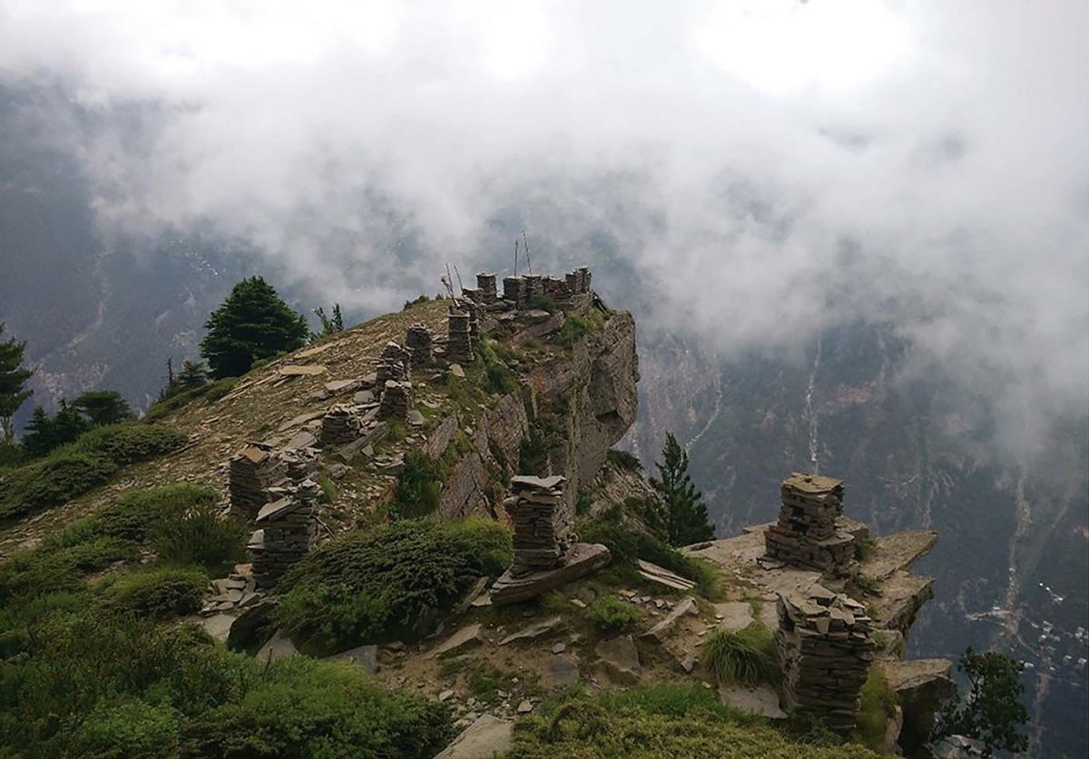
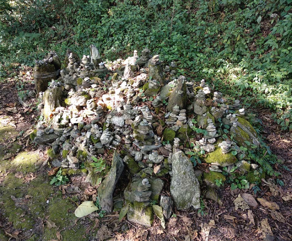
Along the pastures above villages like Kalpa, Pangi, and Roghi on way to Runan-Kanda, are a series of cairns at a nearby ridge. Cairns are human-stacked piles of stones assembled as a part of burial rituals, popular across the Himalayas. These cairns are often located at about 3500 meters or above, as a memorial tomb for departed family members. Every year, during the Dukhraini (festival of mourning) at least one family member visits the cairn to pay their respects to their departed family members. The annual rituals of Dukhraini can at best be understood as intangible ruins of the tangible remains-cairns, which have become a way of acknowledging and honouring the ancestors and their history in these highlands.
These cairns were erected at vantage points on the ridge; often used as geographical markers by those who would frequent these heights and usually indicated proximity to a settlement. However, as societies have become more sedentary and changed in how they move and interact, such landscapes often present a confusing picture of a valley of ruins and death and are often not well understood. Although these ruins are often not well preserved, they nonetheless offer significant insights into how people lived, consumed and interacted centuries ago. For instance, a common practice among highlander families was to accord clan/group identities based on place of origin and direction of their movements. Thus, these tangible ruins of cairns along with their location amalgamated with intangible ruins, such as trail patterns and movements, and became socially institutionalized.
3000 kilometres further east of Kinnaur lies the Dibang valley in the Eastern Himalayas, home of the Mishmi indigenous group. Like many other highland communities, Mishmis are trans-border people living on both sides of the India-China border. They live in the Indian state of Arunachal Pradesh and in the Tibet Autonomous Region (TAR) and Yunnan province of China. In comparison to most other trans-border communities of the Himalayas, the Mishmi are unique as they are not connected through trade and pilgrimage but rather through death. Majority of the Mishmi still follow their own indigenous religion and, as per their belief system, a Mishmi soul travels back to their original home which is their place of origin. Incidentally, the place of their origin is believed to be across the border in TAR and Yunnan province. Their religious priests [Igu] still facilitate in this death ritual, in which the journey of the departed soul is sent back to the place of origin, treading the same trails their ancestors took to reach the homes of the living. However, cross-border government policies have brought about changes that have led to the gradual decline of socio-religious institutions like the Igu. Nonetheless, despite the tremendous social economic transformations on either side of the border, priests on the Indian side still perform Igu rituals and services for Chinese Mishmi. Chinese Mishmi find ingenious ways to send money and the names of their dead relatives, mostly through locals who go hunting in areas where borders are undefined and who occasionally bump into Indian Mishmis. Owing to the contemporary border realities of India and China, valleys and ridges of the Mishmis have been fragmented, constituting an intangible ruin of Mishmi cultural landscape.
Not just what we are left with
The geo-politics between India and China have obviously taken their toll on cross-border cultural linkages of the Mishmis. However, a prominent face from the community, Jibi Phulu, summed up the situation of his community as follows: “I am a proud Indian as long as I am alive. The day I die I am a Chinese”. Mr. Phulu is well aware of the dangers of being misunderstood by some individuals, but the trans-border Mishmis have been forced to come to terms with the contemporary political realities. Like many other highlanders, they negotiate this uncertain geo-political terrain with their social mental maps of cultural similarities on both sides of the border. These mental maps are nothing but intangible ruins of a community.
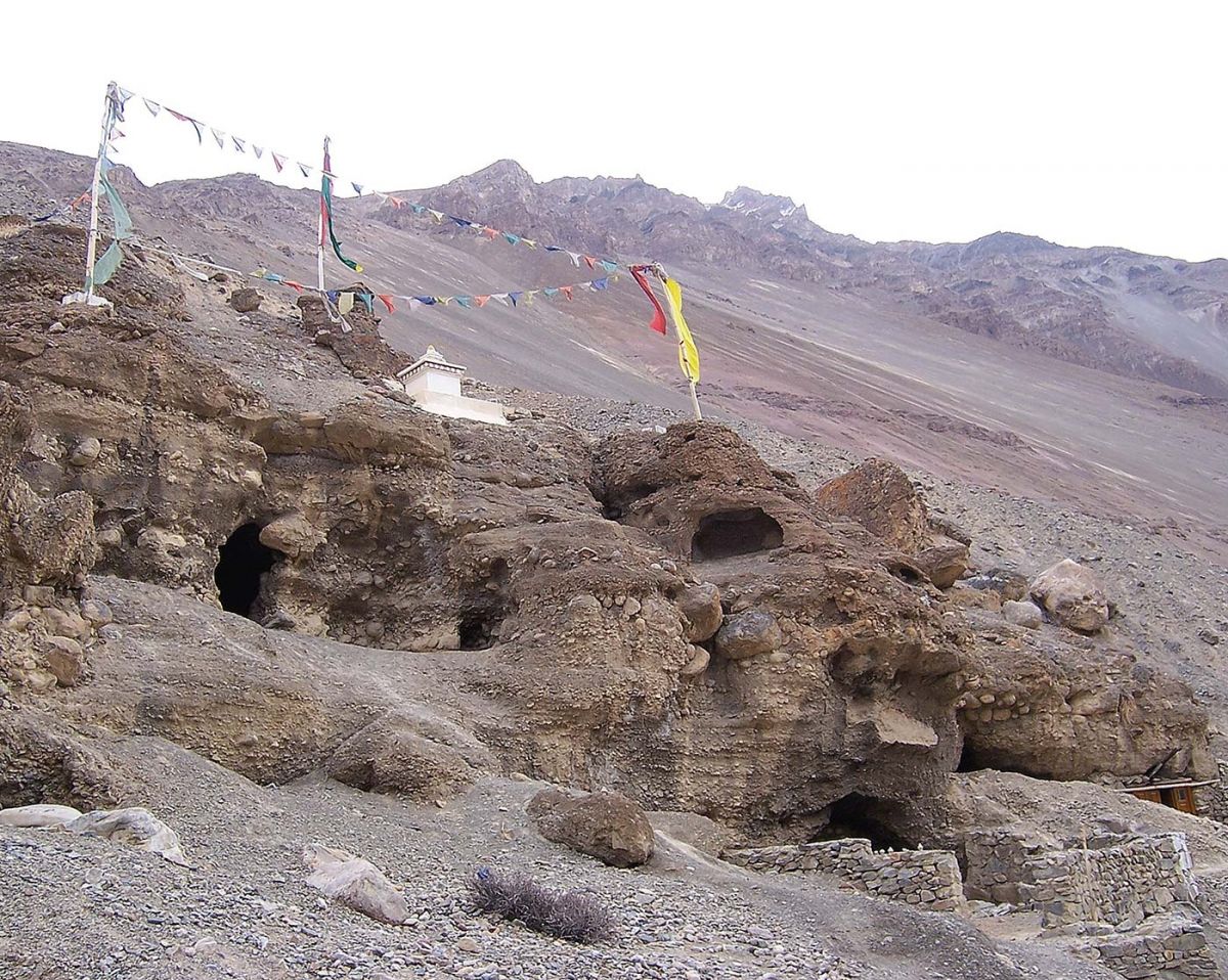
In the Western Himalayas, excavation during road-broadening works unearthed many sites of cist-burials.[2] Locally they were believed to be Muslim graves or graves of Kashmiri people. Accordingly, Kinnauras referred to these as Kha-che Rom-khan. However, scientific studies revealed that some of these graves predated Islam, and the buried bodies shared morphological and genetic proximities with Central-Asian people. This shed light on the ancient space-relation and cultural linkages of the Western Himalayas with Central-Asia. Despite being a site of tangible ruins, the cist-burials of Himachal Pradesh are also a form of a mental-map that has been reshaped over centuries through the oral histories of different groups of communities living in the region. For instance, based on conjecture, the locals started to refer to the cist-burial sites of the central Asian people as Muslim or Kashmiri graves. Only a more nuanced scientific study of these ruins established their linkages to Central Asia beyond doubt, thereby indicating pre-existing cross-border interactions of these Himalayan highlands.[3] Similar road construction and widening activities along Hangrang river in Himachal Pradesh have led to the further disintegration of the caves used by Buddhists monks for their retreats. Nevertheless, the ruins of the caves have been part of unequivocal mental-maps of space relation with Tibet in the context of trade and pilgrimage.
Mental-maps often contradict official maps and may or may not depend on the presence of physical ruins. In the Eastern Himalayan state of Sikkim and neighbouring North Bengal, the ruins of a few forts of the indigenous Lepcha group can be traced from Sikkim’s capital Gangtok. These ruins of forts were of no significance until recently when some Hindu trishuls [tridents] were erected and Lepchas made their “bid for entitlement”, making these ruins “epicentres of renewed claims”.[4] Similarly, another ruin of a prominent Lepcha fort in Kalimpong district of West Bengal holds the memory and claims of the supposedly last Lepcha king in the region. These ruins, of what is supposed to be the queen’s bath, prayer room and the horse stable, are recalled through oral narratives of the Lepchas, although these specificities are not found in official historical records, which only mention the fort in the region.
There are numerous other Lepcha forts located at vantage points of ridges telling the history of a people, who despite being known as the oldest inhabitants of the region, hardly occupy a reasonable space in the written history of Sikkim. Much of Sikkim’s history revolves around the Namgyal dynasty, and therefore these ruins are a vignette into the possible histories of other ethnic groups living in the region. Interestingly, the consecration of a blood pact between Lepchas and Bhutias took place at Kabi (West Sikkim) where Mount Kanchenjunga was invoked and “stones were erected at the spot to mark the event”.[5] These stones, as “megalithic structures of antiquity”,[6] can still be found as ruins of the “historic landmark”,[7] which paved the way for the establishment of the Namgyal dynasty in Sikkim in 1642.
Across the Himalayas, we see different forms and roles of ruins – both tangible and intangible – that allow us to identify and examine the nature of ruins. The above examples from the Western to Eastern Himalayas are indicative of how ruins are not what we are left with, but that what we make of them is what aids us in our understanding of our existence today.
Uttam Lal and Charisma K. Lepcha, Assistant Professors, Sikkim University, India
[1] Sanders, R.A & Porter, P.W. 1974. ‘Shape in Revealed Mental Maps’, Annals of the Association of American Geographers 64(2):258-267. Taylor & Francis.
[2] Nautiyal, V. et al. 2014. ‘Lippa and Kanam: Trans Himalayan Cist burial Culture and Pyrotechnology in Kinnaur, Himachal Pradesh, India’, Antiquity 088(339).
[3] Singh, A.K. 1999. ‘Cist Burials in Kinnaur, Western Himalayas: A Preliminary Report on Recent Discovery’, Central Asiatic Journal 43(2):249-258.
[4] Stoler, A.L. 2008. ‘Imperial Debris: Reflections on Ruins and Ruination’, Cultural Anthroplogy 23(2):191-219, p.198.
[5] Wangchuk, P. & Zulca, M. 2007. Khangchendzonga: Sacred Summit. Kathmandu: PemaWangchuk/Hillside Press, p.54.
[6] Mullard, S. 2011. Opening the Hidden Land: State Formation and the Construction of Sikkimese History. Leiden: Brill, p.41.
[7] Foning, A.R. 1987. Lepcha, My Vanishing Tribe. New Delhi: Sterling Publications, p.34.


