Recentering Climate Migration in the Bengal Delta
Mohammed Kabir Hossain, a rickshaw-driver by profession, is one of many environmental migrants who moved to the second-tier port city of Mongla, Bangladesh. “Because of salinity and flooding, there are limited livelihood opportunities in my village. But here, I can make good money,” he says. He returns home during the cropping and harvest seasons and Ramadan. Kabir is one of the thousands of people who are displaced every year in the Ganges-Brahmaputra delta due to the rising sea level, dynamic shoreline, and annual cyclones. Due to the lack of a global legal definition, it is impossible to acknowledge the existence of this group of displaced. Can the climate migrants be recognised – in this case in the Bengal delta?
The human face of climate change
Climate-induced migration is the human face of climate change. Rising temperatures and changing weather patterns are causing sea-level rises, flash floods, forest fires, unseasonal rains, and drought. Depriving millions of people of their homes and livelihoods, these gradual or sudden changes in the environment are yet to be recognised as legitimate reasons for forced displacement. They force the affected to undertake arduous journeys to nearby cities in search of new means of sustenance. Their families are forced to undertake adaptive measures in the hope of reconstructing their lives, livelihoods, and homes. The cyclical movement between the source and destination is a common pattern adopted by the migrants to retain their assets and social capital at source, while constructing new livelihoods in the destination city.
Twenty-five million people have already been displaced due to environmental disasters, 1 with Low Elevation Coastal Zones (LECZs) in developing countries the most adversely affected. These zones are less than 10 metres above sea level and yet host 10 percent of the world’s population. In developing countries, the marginalised populations in these zones are often the most vulnerable. Due to weak governance systems and lack of support resources they are pushed into a “negative vulnerability cycle.” Environmental disasters deprive them of their livelihood and/or their home, forcing them to move to nearby urban areas within or across borders to find sustenance for themselves and their families. They are forced to inhabit the informal fringes of destination cities, which invariably keeps them outside formal governance systems. Insufficient support at source pushes them into exploitative and discriminating conditions in cities. Such movement, while offering them immediate cash flow, does nothing to strengthen their socio-economic condition. It leads, rather, to debt, pushing them further into poverty. The consequent loss of land, tangible and intangible assets, and cultural identity stunts the growth and development of affected families for generations.
The impact of the COVID-19 pandemic on migrant populations has reaffirmed the appalling lack of support systems or resources that makes these the worst affected people during a crisis. Cities across the world witnessed the vulnerabilities of their temporary residents during the various lockdowns of 2019-2021. However, the Global South, especially India, was confronted with the stark inequalities and policy gaps that caused the mass exodus of migrants from cities. The fear of the disease, mistrust in the system, and job and housing insecurity forced migrants to undertake arduous journeys back home. Municipal governments were scrambling for data and resources to facilitate relief for the workers who were emerging in huge numbers. The crisis highlighted the inherent role of NGOs and civil society organisations in stabilising the situation, as they had maximum outreach and impact. This refined the discourse on internal migration, calling for inclusive development, policy reforms, and collaborative action between all stakeholders at the destination and the source.
The 2021 Haiti Earthquake is another example of displacement and loss caused by a climate crisis. While the Caribbean nation has always been prone to natural disasters, their pace and ferocity has increased due to climate change. With the government struggling to provide healthcare, aid, and shelter, the affected were left to fend for themselves in an environment where their immediate community was their only support. This comes at a time when people were still recovering from the 2010 earthquake, with over 32,000 people (official estimate) still residing in camps. 2
The proposal in this paper presents a regionally inclusive development strategy for climate migrants from the LECZs in the Ganges-Brahmaputra and Bengal deltas. Through a multi-scalar strategy, it defines a new region with a network of clusters protected by traditional water-management systems. This strategy redefines the functional relationship between the city (in this case Kolkata), the proposed urban-rural clusters, and affected villages in the Sundarbans.

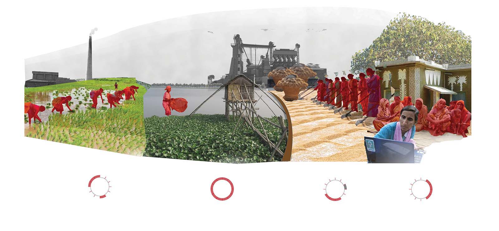
Fig. 1: Dominant seasonal migration pattern of the Sundarbans (Figure by Asmeeta Das Sharma, 2019).
Climate migration: definition and consequences
In 1985, Essam El-Hinnawi placed human migration in the context of climate change for the first time by coining the term “environmental refugees.” Since then, numerous scholars and international agencies have scrutinised the term and put forward their own definitions. The lack of a cohesive legal definition has led to reduced visibility for the migrants, further exacerbating their loss of identity, culture, and at times even citizenship. 3 Circular migration has been noted as the most common initial form of adaptation, with working members from displaced populations moving to nearby urban areas. These areas are usually an overnight journey away, allowing the migrants to maintain social capital at source. They undertake semi-skilled or unskilled informal jobs, which give them an unreliablesource of income and no stability.
The movement of people puts immense pressure on the destination urban areas and the development of the larger region. Informal urbanisation and “invisible” floating populations put excessive stress on the resources of the region The demographic shift from the rural to urban leads to extended urbanisation in the destination urban areas and stunted development or abandonment of the source urban or rural areas. This disproportionate regional development causes an imbalance in the economic and infrastructural growth within the region. Population density, food and water security, and the infrastructural capacity of the urban areas are all adversely affected, creating a sense of insecurity in the host population. Due to the undocumented nature of these movements, the migrants remain outside the scope of governance structures in most countries. Furthermore, the uneven distribution of resources impacts the economic stability and safety of the region. Increased poverty levels lead to the reallocation of resources to mitigate this rise and to stabilise the labour surplus. 4 This reduces market opportunities and salaries, pushing higher skilled classes to emigrate. This “brain drain” further hollows out the economy. 5 Overburdened with these complex challenges in addition to climate change, developing nations struggle to achieve equitable quality of life for their citizens. 6
Circular migration has also been a dominant adaptation measure in the Bengal delta. Migrants oscillate between source and destination until they collect sufficient resources to settle down legally (or illegally) in one of them. 7 This cyclical movement has been noted to create a triple-win situation by the United Nations Economic Commission for Europe. When carried out formally, it has been found to be beneficial for the destination, source, and migrants alike. The migrants contribute to economic production and alleviate labour shortages in cities, while remitting support back home in the form of financial and human capital. Countries like New Zealand and Canada have formal seasonal worker programmes, which allow circular movement of workers to bridge the labour gap in the horticulture and agriculture sector. 8
However, in developing countries, this phenomenon is yet to be formally recognised and incorporated into policy frameworks. This leads to the marginalisation of the migrants and burdens the region rather than triggering comprehensive development. Undocumented movement and employment fuel informality in the city, causing a resource crunch for the host population and further deteriorating the quality of life for all citizens. The temporary nature of the employment, and the limited cash flow, leaves migrant families with minimal savings, forcing them to take loans in times of need. This triggers a debt cycle that pushes families into increasing socio-economic vulnerability. In this situation, repeated environmental changes or disasters cause further damage, often pushing them into poverty.
The plight of the Sundarbans
The Bengal delta is the largest transboundary geological delta in the world. With an area of more than 105,000 square kilometres, 60 percent of it lies in Bangladesh while 40 percent is in West Bengal. Home to two mega-metropolitan cities – Kolkata and Dhaka – the delta has an average density of 200 people per square kilometre. The high population density of the region is partly responsible for its inadequate infrastructure and disproportionate access to amenities and institutions. Due to its geographical location, the region has been constantly under threat of natural disasters like cyclones and earthquakes. Climate change has exacerbated this significantly through tidal inundation, rising sea levels, heavier rainfall, river erosion, water salination, and increased cyclonic activity. This highlights the area as one of the most vulnerable to climate risk in the world. 9

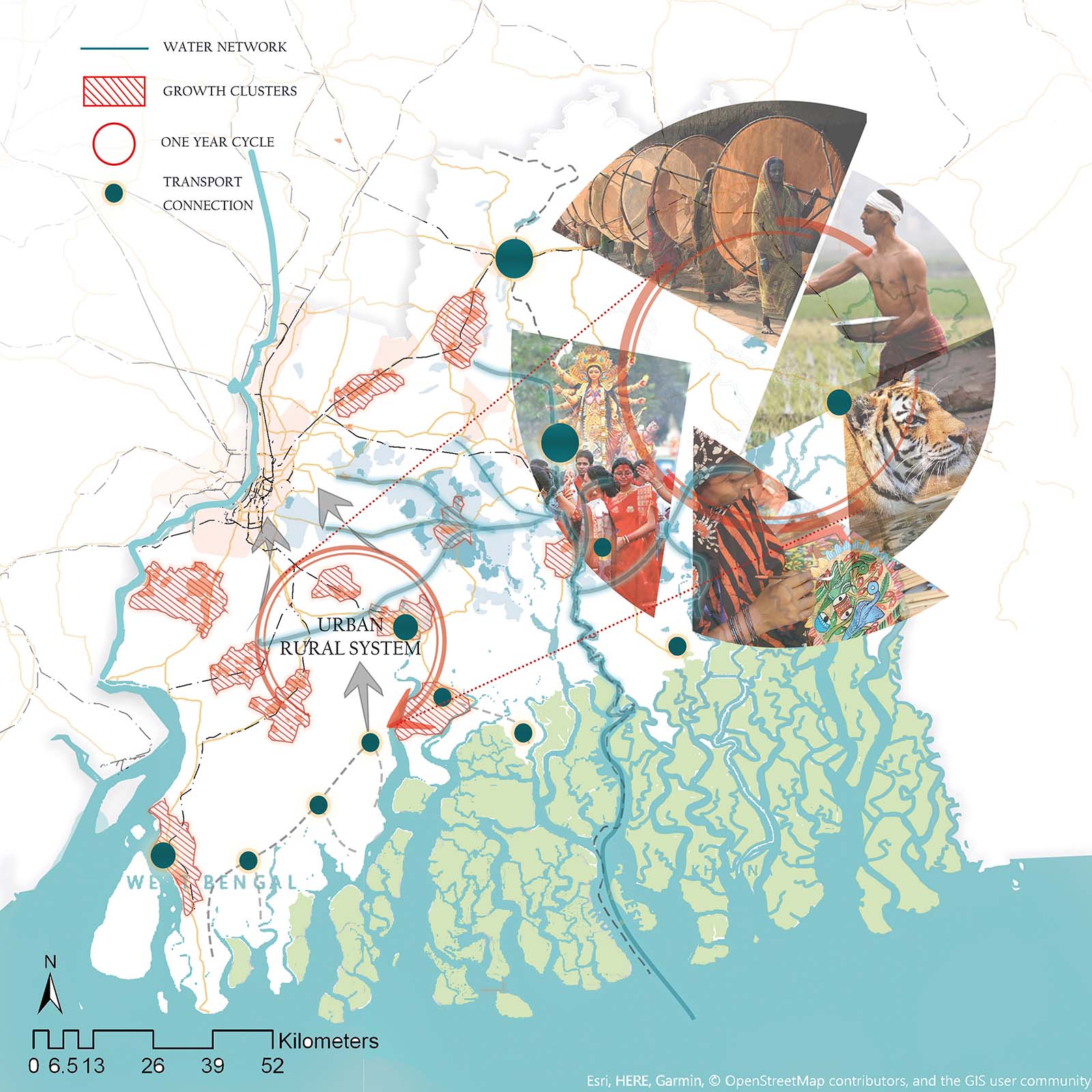
Fig. 2: Regional vision for the Ganges-Brahmaputra Delta (Figure by Asmeeta Das Sharma, 2019).
Plagued by annual cyclones, which disrupt life for three to four months of the year, the coastal areas in the region are the worst hit. Known as the Sundarbans, this is the largest mangrove forest and swamp in the world. Spread over 54 islands, this eco-terrestrial zone is home to tribal villages (on the Indian side of the delta) as well as to a unique variety of flora and fauna. The population’s primary occupation is agriculture, making the region’s economy, food security, and social structure highly dependent on the physical environment. With rising sea levels and the changing course of river streams, the islands (known as “chars”) constantly gain and lose land mass. The soil is increasingly plagued by salination, making it unfit for cultivation and slowly diminishing sources of fresh water (something also seen in Sun Woo Kim’s paper, “Establishing a Regional Framework for Migrants in Semarang”). Research estimates that 40 million people will be displaced from the region by 2050.
Restructuring the Bengal delta
To address this situation, this article proposes a strategy to bring alternate livelihoods closer to people’s homes, trigger polycentric development, and reinforce traditional cultural knowledge. This is a regional spatial and governance strategy which implements the Sustainable Livelihood Framework to pre-emptively accommodate climate migrants and their circular lifestyle in the spatial and economic development plans of the delta. It presents a two-point perspective on the problem with the aim of empowering migrants and triggering positive development.
The proposal works across three scales: the regional; the functional relationship between village, town, and city; and the local (town) level. Clusters for potential development are defined between the city and coastal villages to accommodate the displaced and to decongest Kolkata. These clusters are connected to the city and villages to enable easy market access for migrants as well as for the towns’ industries. These towns are the hubs of the clusters, where functions have been added to activate town economies and generate livelihoods for the migrants.

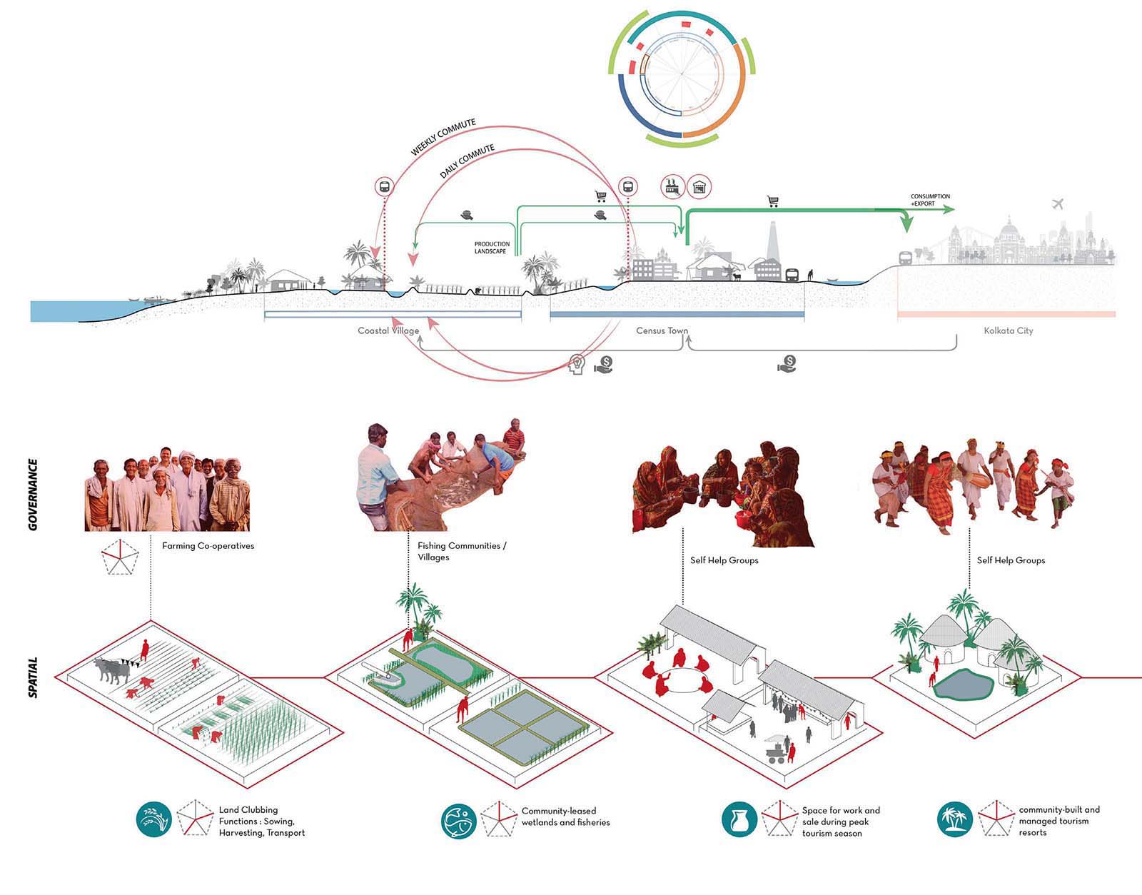
Fig. 3: Restructuring opportunities in the region to activate the Census Towns (Figure by Asmeeta Das Sharma, 2019).
The region
A new region has been defined to restructure the movement of the climate migrants. It is based on an urban-rural system that identifies and respects the spatial integrity and functions of the city, emerging towns, and the villages, but which re-focuses on the towns as engines of economic development. It boosts town economies to accommodate livelihood opportunities for the migrants and to meet the demands of traditional economies. This makes the town a processing unit and economic hub for the rural hinterland and a supplier of finished goods and services to the city.
This regional strategy has four key principles:
- Polycentric Development: There is an urgent need to shift to polycentricity in this predominantly monocentric region. This region is primarily dependant on agriculture and aquaculture for employment, with limited processing and storage facilities (concentrated in the city). This concentration of economic activities in the city has led to extended urbanisation. The new strategy proposed here introduces alternative clusters for urban development, which form a network with existing road and rail infrastructure, connecting them directly to the city of Kolkata. They have been termed Growth Clusters and consist of urban and rural settlements. Together, these act as processing units for the surrounding hinterland. They not only act as economic hubs, but also as a safe haven for climate migrants in times of disaster. Stable economic opportunities on the mainland allow migrants to practice sustainable livelihoods and in turn increase their resilience. The boundaries of the clusters are defined by analysing the existing economy, processing industry, demography, and the nature of the towns.
- Connectivity: Given the lack of transport infrastructure in the villages, direct road and ferry connections from the highway are proposed to smooth movement. This will enable migrants to make daily or weekly trips home and pre-emptively evacuate during a disaster. A central organising body will manage all existing ferry routes to connect the coastal island populations to the mainland. Small multi-modal hubs are proposed in demarcated growth clusters to connect to the city and the village. A public-private-partnership model will fund the infrastructure and manage the transport.
- Flood and Water Management: Floods disrupt people’s lives for three to four months of the year. Traditional flood-management systems of small ponds and canals have been disrupted due to rapid urbanisation. To make room for flood water, a system of wetlands has been designed to carry water from the household scale to the cluster and connect to the main river stream. The wetlands will be owned by communities and will generate economic value through pisciculture and organic waste treatment.
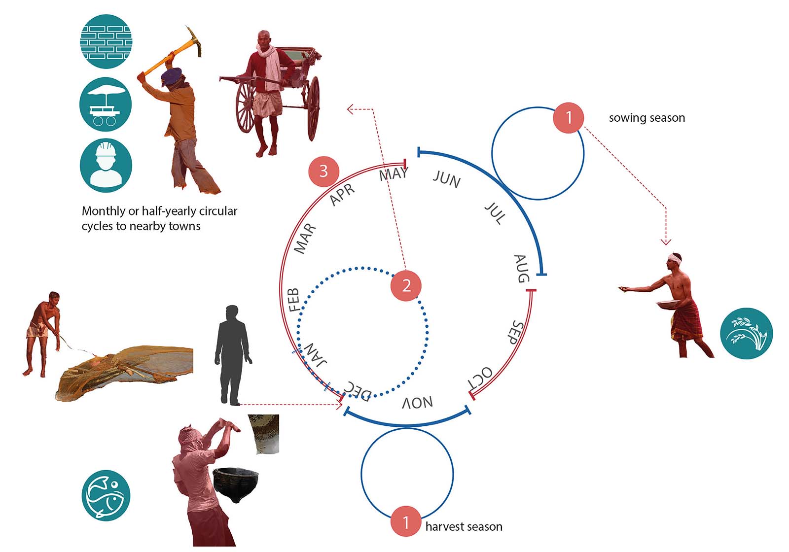
- Traditional Knowledge Economies: An analysis of existing industries and small-scale processing units highlights the existing economic strengths of the Growth Clusters. These functions were mapped on a timeline to create a seasonal calendar for livelihoods [Fig. 1]. New processes are proposed to fill in gaps in the calendar, generating a year-long demand for labour. This will ensure that traditional industries will be protected through a demand for traditional knowledge and expertise. This will allow migrants to freely practice their trans-local lifestyles and propagate their traditional knowledge systems.
Functional relationships
The Growth Clusters are meant to localise the processing of raw materials produced in the hinterlands. They provide infrastructure and expertise closer to the producers. Each cluster has a starter group consisting of local NGOs, technical experts, and local government officials. This group generates a business model after assessing the potential of the surrounding region and implementing the framework provided. It then pitches this model to the local governments of the surrounding towns and villages within the defined cluster. Contracts or memoranda of understanding will procure materials directly and share profits from the processed and distributed products.
With the aim of decentralising power, this partnership will create a competitive environment within and between the clusters to boost their industries and generate more livelihoods. The industrial spaces allocated within the clusters will be multifunctional in nature. They will host the various activities of the seasonal industries as well as provide social support, like skill-development programmes, disaster training, and women and child welfare programs. This structural spatial plan of Growth Clusters will be fed by local area plans developed by local governments in the towns and villages and will further inform the overall plan for the new region.

Fig. 4: Seasonal occupations practiced by migrants (Figure by Asmeeta Das Sharma, 2019).
Local
At the local level, the proposal defines guidelines for spatial growth via a set of six land-use principles that will regulate the growth of the Growth Clusters, prevent extended urbanisation, and promote sustainable development:
- Connectivity: Each town should have a minimum of two access points to regional transport services like trains or busses. These should be inviting and equipped with information points to enable migrants to orient themselves upon arrival. Existing roads should be refurbished to service 800-metre-wide blocks, and original informal pedestrian pathways should be retained to maintain existing social nodes.
- Zoning: A zoning plan marking commercial zones, public space, land for new industries, and supporting social infrastructure should be generated through a participatory process.
- Preservation: Wetlands and water-bodies should be marked as Preserved Zones with strict regulations against building activities. All water-bodies should be connected through bio-swales, depending on the slope of land and the road infrastructure. This storm-water network will carry excess water and reduce flood risk.
- Community space: Each 800-metre block should have a community space (existing or new), which should be demarcated as a no-build zone.
- Economic Zone: These zones should be planned at the edges of towns and are to be directly serviceable by public transport and closer to production landscapes.
- Organic Sewage Treatment: Each settlement has adjacent natural wetlands (some of which have been covered by urbanisation). These wetlands should be used for organic sewage treatment and managed by contracted migrant communities who can use them to practice traditional forms of pisciculture and hydroponics.
Creating a safety net
Current post-disaster response mechanisms have been constantly scrutinised by researchers and practitioners. This project presents a more inclusive, development-based approach by advocating the need for including spatial planning and mindful governance in collaboration with disaster-management regimes. There is a need to pre-emptively include disaster vulnerability in planning tools for affected regions to safeguard residents.
The model proposes one such method of doing this. It functionally reconfigures the Bengal delta to strengthen its existing and adapted social, human, and natural capital. Emphasising the need to demarcate ecological and functional regions, it builds on the transitional nature of urban and peri-urban settlements (including towns) and redefines their relationship with the city and the village.
Climate migrants need a robust safety net to be able to recover and grow. At the frontline of disaster, these populations silently face the wrath of environmental change. With every country battling these consequences in its own way, a renewed focus on the human, social capital of ecological regions will help mitigate the negative impacts on people’s lives. As climate change increasingly becomes a stark reality, climate migrants – the human face of these disasters – urgently need global action to minimise the impacts. 10
Asmeeta Das Sharma, urban planner and strategist at NACO, Royal Haskoning DHV, the Netherlands, asmeeta_das@hotmail.com