Mapping borders in times of uncertainty
In 1889, the government office Huidian guan會典館 [Office of Collected Statutes] ordered every province to collect and make maps of their territory. As a result, a year later, a special office for making maps was established, and in 1892, the Huidian guan made a second announcement, specifying the technical regulations for the project. The resulting atlas that combined the surveys from all provinces was titled Daqing huidian yutu 大清會典輿圖 [Maps of the Great Qing by the Huidian Office].
Every province exceeded the given time limit of one year, most of them finishing within three to five years. Some of the maps were printed, while some were manuscript drafts when the provinces sent the maps to the Huidian guan. The quality of the maps varied from only slightly updated old maps to excellent new surveys. On the Yunnan quansheng yutu 雲南全省輿圖 [Complete Maps of Yunnan Province], the atlas of Yunnan Province made for the Daqing huidian yutu, for example, only the regions around the capital of Yunnan used new surveying techniques, while other parts of the province continued to use old mapping material, only updating the legends, and adding a grid with latitude and longitude. This situation of the mapping of Yunnan province is partly representational of other regions in China at that time.
Today, at least four manuscript sets of the atlas of Yunnan quansheng yutu are extant. Two of them are kept in Beijing, one in Chengdu, and one in Kunming. As the border between China and French Annam was disputed and undergoing changes during the time when the maps had to be sent to the Huidian guan, studying these maps and other maps of Yunnan related to them, reveals how late Qing central and local government officials carefully edited information about borders.
In 1896, the previous governor of Yunnan and Guizhou, Song Fan 崧蕃 (?–1905), presented the maps to the emperor. From his memorial to the throne, we learn that it were indeed officials in Yunnan province who compiled the maps. Material from every county arrived in the provincial capital, Kunming, where a committee combined the information from all around Yunnan and corrected errors.

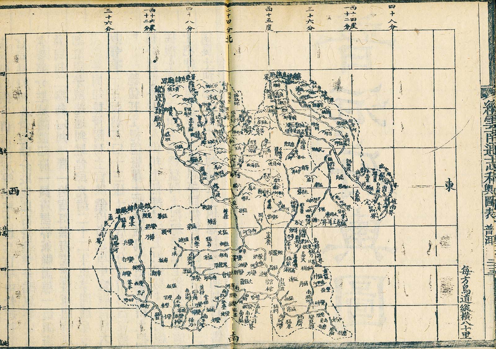
Fig. 3: The Map of Pu’er 普洱 from Tang Jiong’s Xu Yunnan tongzhi. At the Southwestern border, Mengwu and Wude are marked.
After the completion of the maps in 1894, the political situation changed at the border between China and French Annam, and a year later, Mengwu 猛烏 and Wude烏得 (today in northern Laos), were signed over to French Annam in a treaty after the Sino–Japanese war. As the office for compiling the Daqing huidian yutu urged the province to quickly send the documents in 1896, the compilers of the Yunnan province atlas only had time to add notes to each instance of Mengwu and Wude appearing in the atlas in each of the four editions, explaining the disputed nature. The governor of Yunnan also sent another copy of the atlas to the Guangxu emperor (r.1875–1908), and two further copies were archived in the local government – a standard administrative procedure. This is why we have four similar drafts of the Yunnan quansheng yutu today.
The Daqing huidian yutu also influenced new local gazetteers. While the map material in Ruan Yuan’s 阮元 (1764–1849) Yunnan tongzhi gao 雲南通志稿 and the 1894 Yunnan tongzhi 雲南通志 was still based on surveys of the Kangxi and Qianlong periods, Tang Jiong’s 唐炯 (1829–1909) Xu Yunnan tongzhi gao 續雲南通志稿, printed in 1898 and 1901, already uses the new mapping style of the Daqing huidian yutu (fig.3). In his gazetteers, Tang Jiong provides clear written descriptions about the situation of the French–Chinese border at Mengwu and Wude, thus accomplishing what the compilers of the Yunnan quansheng yutu had not been able to do due to time constraints. His two editions of the Xu Yunnan tongzhi gao were produced in Sichuan, and so one set of the Yunnan quansheng yutu is now collected in Chengdu.
The manuscripts of the Yunnan quansheng yutu are important documents as they preserve the original outline of the maps presented to the central government. Their editing history shows us that late Qing mapmakers paid great attention to changing borders and that they and compilers of gazetteers reacted quickly to new political situations.
Qin Ying is Associate Professor at the College of Historical Culture and Tourism, Southwest Minzu University qinying_yb@163.com