At the borders of Qing imperial cartography
Qing China’s Kangxi (1661–1722), Yongzheng (1722–1735), and Qianlong (1735–1796) emperors each produced large atlases of the empire they ruled, entitled Huangyu quan(lan) tu 皇輿全(覽)圖 [Overview Maps of Imperial Territories]. Different editions were produced during each of these reigns, some in the form of atlases, some in the form of large multi-sheet maps.
Maps without borders?
The Kangxi atlas covers Qing controlled territories and adjacent tributary lands such as Korea and Tibet. To this, the Yongzheng map (see QingMaps.org) adds all of the Russian Empire up to Riga and Asia Minor, whereas the Qianlong map expands this scope even further to include the northern subcontinent and the Arabian Peninsula. This raises the question of how the Qing depicted its borders on these “Overview Maps of Imperial Territories”.
A quick look shows that no borders are depicted in the north, including in areas where the successive maps expanded their scope; there is no trace of a border between the Qing and Russian empires, for example, despite the existence of two border treaties, Nerchinsk (1689) and Kyakhta (1727). Another example is the apparent absence of the Qing–Korean border. In contrast, in the southwest of Qing territories, dotted lines trace the border that Yunnan province shared with what is now Myanmar, Laos, and Vietnam. Similarly, although only on the Kangxi and Yongzheng maps, dotted lines surround unmapped blank pockets in Guizhou province that constituted tribal lands. Thus, it seems external borders in the southwest are clearly indicated, whereas legally confirmed borders in the north and northwest did not find their way onto these large multi-sheet maps. How can we explain this paradox?
Space versus territory
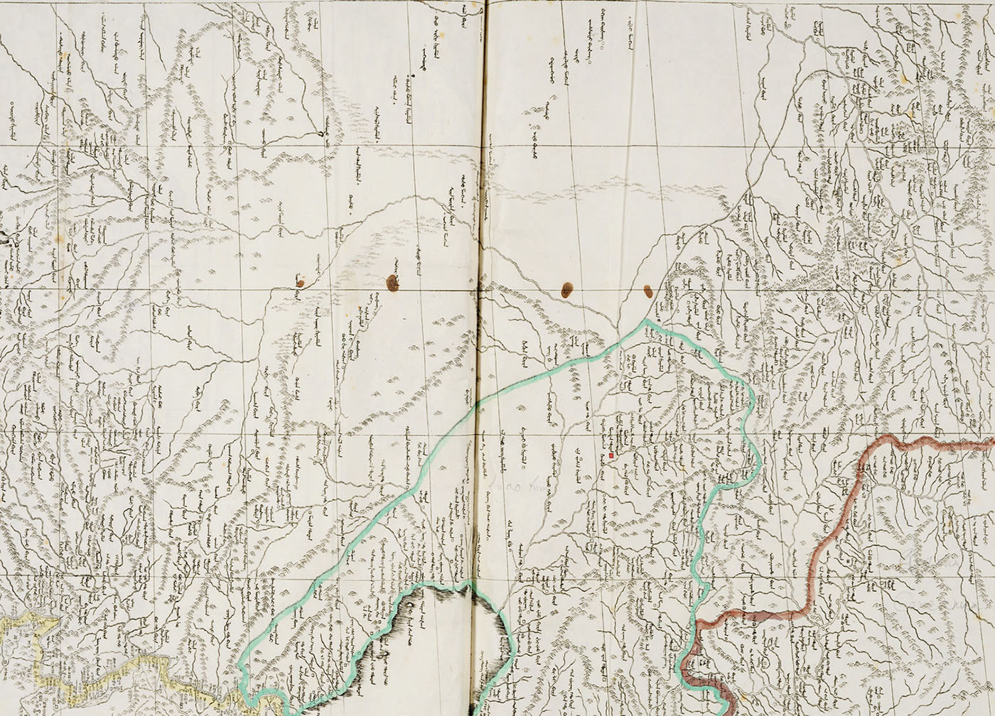
A closer look reveals that borders internal to the Qing are emphasized and exaggerated. One such border is the Willow Palisade, long since in disrepair by the time these atlases were produced, which separated Mongols from Manchus and runs from the Great Wall northeast of Beijing all the way around Mukden (Shenyang) and Kirin Hoton (Jilin), with one stretch branching off towards the (undepicted) border with Korea. On the other hand, there is the Great Wall itself, most of it built as a defensive structure during the late Ming precisely in order to keep the Manchu at bay. Like the Willow Palisade, this border is greatly exaggerated, giving the false impression that it formed one uninterrupted and uniform wall from east to west (fig.2). With this, Qing court maps stress one of the hallmarks of Qing rule: the separate administration, territorially defined, of Manchu, Mongols, and Han (later also including the Tibetans and the mostly Muslim population in the ‘western regions’ xiyu 西域).

Fig. 2: 1719 copperplate version of the Kangxi-era multi-sheet map. Borders highlighted in print and in colour include the Willow Palisade (centre, in green); and the Great Wall (bottom left, in yellow). Although colour was also applied to highlight the border between Qing and Korean lands (bottom right, in brown), this border is not indicated on the print itself. About 40-64 cm. Royal Library of Belgium, LP VB 11.283 E (2), fol. 10.
The absence of legally defined external borders combined with a strong emphasis on internal borders can be understood by considering the difference between imperial territory and its prerequisite, imperial space. Taken as a whole, these maps communicate Qing space and therefore leave open the possibility of further expansion and conquest, particularly in the direction of the court’s northwest-oriented gaze. On the other hand, it was imperative for this minority-ruled empire to distinguish between the Manchu, Mongol and Han territories it effectively controlled. Beyond this, Tibetan and Korean tributary lands were also covered under the imperial umbrella, but these lands are mostly separated by river systems so that no border needed to be drawn. In the southwest, where the dotted line delineates Yunnan, we are in fact also dealing with an internal border of sorts, separating the province from more tributary lands (left blank in this case). The fact that provinces are also separated by a dotted line where no natural border is present confirms this thesis.
In short, whereas these court maps as a whole communicate a universal and therefore a theoretically borderless imperial space, they clearly distinguish among the imperial territories, including tributary states that made up and defined the Qing order. In other words, it is not at the edge but at the very center of these maps that we find ourselves at the borders of Qing cartography.
Mario Cams is Assistant Professor at the Department of History, University of Macau mariocams@um.edu.m